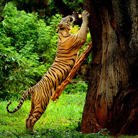
Muthanga wild life sanctuary

Muthanga Wildlife Sanctuary, established in 1973 is 16 km away from Sulthan Bathery. Connecting the Bandipur and Nagarhole parks in Karnataka; and Mudualai in Tamil Nadu, this 345 square kilometre rainforest is home to a wide variety of flora and fauna. This Wildlife Sanctuary mainly consists of four major ranges. They are Sulthan Bathery, Kurichiat, Tholpetty and Muthanga. This Sanctuary is now an integral part of the Nilgiri Biosphere Reserve. Muthanga Wildlife Sanctuary, more popularly known as Wayanad Wildlife Sanctuary is the second largest wildlife Sanctuary in Kerala.
Edakkal Caves

Located 16km from Sulthan Bathery, the Edakkal Caves are situated on top of the Ambukuthi Mala or Ambukuthi hills. One has to trek up the Ambukuthi Mala to reach the cave. The structure of Edakkal Caves is such that a big rock got wedged between two bigger rocks to form a cave. Thus, from the cave structure was the name Edakkal Caves was derived which means stone in between (“edai” meaning in between and “kal” meaning stone).Most scientists are of the belief that the Edakkal Caves is not literally a cave. But, it’s a fissure that split the rock due to some climatic changes or natural causes .
Karapuzha Dam

Karapuzha Dam located in the Wayanad district of Kerala, is one of the biggest earth dams in India. Karapuzha Dam is located in the greenish and natural regions of Wayanad, Kerala on the Karapuzha River, a tributary of the Kabini River. Construction on the dam began in 1977 and it was complete in 2004. The purpose of the dam is irrigation and it left and right bank canals are still under construction.Karapuzha Dam is located 16 km from Kalpetta. It is one of the most easily reachable places in Wayanad since it can be easily accessible from nearest cities like Kozhikode..
Banasura Sagar Dam

Located at the foot of Banasura hill, Banasura Sagar Dam encloses the water from Karamanathodu tributary of the Kabini River. This dam is located at about 21 km from Kalpetta in the Wayanad district of Kerala. The dam was a part of the Indian Banasurasagar Project which was started in 1979. The project consisted of a dam and a canal project. This project was undertaken with major goals like supporting the Kakkayam Hydroelectric power project and also to satisfy the need of water for irrigation and drinking purposes.. .
Soojipara

Soochipara Falls also known as Sentinel Rock Waterfalls is a three-tiered waterfall in Vellarimala, Wayanad, surrounded by Deciduous, Evergreen and Montane forests. Locally referred to as Soochipara ("Soochi" meaning "Needle" and "Para" meaning "Rock"), the 15-20 minute drive from Meppadi to Sentinel Rock Waterfalls offers scenic views of some of the best tea estates in Wayanad. The Sentinel Rock Waterfalls is 200 metres (656 feet) and offers a cliff face that is ideal for rock climbing. The water from Soochipara Falls later joins Chulika River or popularly known as Chaliyar River after Velarimala Hills near Cherambadi (Tamil Nadu) in Kerala..
Kuruva Island

Kuruva Dweep or Kuruva Island is a 950-acre uninhabited island covered with dense and evergreen forests. This island lies on one of the tributaries of river Kabani in the Wayanad district of Kerala. Kuruva Dweep is about 15 km from Manathavady and 58 km from Sulthan Batheri. Kuruva Dweep, being uninhabited and covered with dense and evergreen forests, is home to some rare species of flora and fauna. To get to the island, one can access the river by using rafts or fibre boats provided and maintained by Kerala Tourism Department.In order to protect .
Pookode Lake

Nestled amidst the green forests and scenic mountain slopes lie the Pookode Lake at an altitude of about 770 metres. The Pookode Lake is a fresh water lake, the only one of its kind that has the shape of India’s map. The lake is famous for the picturesque views of nature all around. Pookode Lake is located at about 15 km away from Kalpetta in the Wayanad district of Kerala. Sprawling across an area of 8.5 hectares, Pookode Lake has a depth of 6.5 metres.Pethia pookodensis, a type of fish belonging to the Cyprinid fish species is believed to be found only in the Pookode Lake in India. The fish belonging to this species can grow up to a length of 4.3 centimetres.
Lakkidi View Point

Lakkidiis the gateway of Wayanad district of Kerala state, south India. Lakkidi is one of the highest locations in Wayanad. It is situated 700 m above mean sea level, atop Thamarassery ghat pass. Vythiri is the nearest town, just 5 km from Lakkidi Chain tree, Pookot Lake, Sight seeing point on ghat road and number of tourist resorts are within 5 km from Lakkidi. It is about 58 km northeast of Kozhikode district. The lofty mountain peaks, the gurgling stream, luxuriant vegetation and the bird's eye view of the deep valley on the south, with its winding roads, are breathtaking. .

